Melting Glaciers and Unstable Mountains: What Is Happening in the Karakoram?
Karakoram glaciers are changing unevenly as warming reshapes ice, glacial lakes, river timing and risks for mountain communities across Pakistan.
By Wajeeha Iqbal
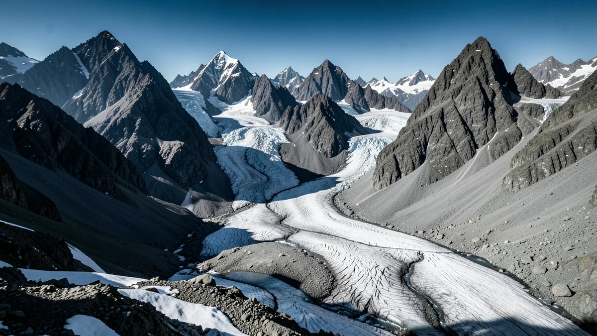
The phrase Karakoram glaciers climate change brings together two facts that are easy to state and difficult to explain. The world is warming, and glaciers across High Mountain Asia are losing ice. Yet the Karakoram has long contained glaciers that behaved differently from many of their Himalayan neighbors—some near balance, some advancing, some surging, and others retreating. That complexity has sometimes been used to imply that the region is protected from climate change. It is not.
The scientifically useful picture is neither “every glacier is disappearing at the same speed” nor “Karakoram ice is fine.” It is a landscape of different elevations, aspects, debris covers, snowfall regimes and internal glacier dynamics, all responding to a changing climate in uneven ways. The consequences extend far beyond mountaineering conditions. They reach villages, rivers, irrigation systems, roads, hydropower, ecosystems and the long-term water security of the Indus basin.
Pakistan’s high-mountain ice system
Northern Pakistan sits where the Karakoram, Hindu Kush and Himalaya meet. The region contains some of the largest bodies of ice outside the polar areas, including long valley glaciers whose meltwater contributes to river systems used by communities far downstream. Snow and glacier ice act as stored water, releasing it on seasonal and longer timescales.
It is important to separate snow, glaciers and rivers. Seasonal snow may melt within months. A glacier is accumulated snow transformed into flowing ice over time. River discharge combines rainfall, snowmelt, glacier melt and groundwater, with the proportions varying by basin and season. A low-snow year can affect water even when glacier area changes slowly; a hot period can increase meltwater temporarily even while it reduces the long-term ice reserve.
That is why the condition of a glacier cannot be judged by whether a river currently looks full. Additional melting may initially add water. Later, after enough ice has been lost, the contribution can decline. Researchers sometimes describe this turning point as “peak water,” but its date differs among basins and carries substantial uncertainty.
What glacier melting actually means
A glacier gains mass mainly through snowfall and loses it through melting, sublimation and the break-off of ice where relevant. The difference is its mass balance. A glacier with a negative balance over time is losing stored ice even if its terminus briefly advances. Conversely, the end of a glacier may retreat while some upper area receives abundant snow.
Surface appearance can mislead. Thick rock debris may insulate ice and slow melting below it, while thin dark debris absorbs solar energy and can increase melting. Melt ponds and streams can carry heat into the ice. Steep tributaries can deliver avalanches that nourish one glacier more than another. A glacier’s response may also lag behind climate conditions.
Satellite measurements, field stakes, weather records and models therefore have to be combined. In the Karakoram, field access is exceptionally difficult. Clouds, snow cover, debris and political boundaries add gaps. Scientific uncertainty is not evidence that nothing is happening; it defines how confidently particular changes can be assigned and projected.
The Karakoram anomaly—and why it is not an exemption
For years, researchers used “Karakoram anomaly” to describe the near-balanced or slightly positive mass balance observed over parts of the Karakoram and neighboring western Kunlun while many other mountain glaciers were losing mass. Several explanations have been investigated, including high-altitude snowfall, summer cloud and cooling influences, regional circulation, glacier geometry and the unusual number of surge-type glaciers.
The label was always regional and time-bound. It never meant every glacier was growing. Studies have found strong variation within the Karakoram, and more recent measurements have examined whether the anomaly is weakening or ending in parts of the region. The Intergovernmental Panel on Climate Change has treated the phenomenon as a real regional contrast while projecting substantial future ice loss in High Mountain Asia under continued warming.
A surge adds another complication. A surging glacier can move large amounts of ice rapidly from an upper reservoir toward its tongue, causing dramatic advance without a climate-driven gain in total mass. Such motion can block rivers, form ice-dammed lakes or disrupt routes. An advancing front therefore does not prove that the glacier is “healthy.”
The most accurate 2026 conclusion is that regional glacier loss is accelerating across the wider Hindu Kush Himalaya, while the Karakoram retains important local differences that must be monitored rather than averaged away. ICIMOD reported in March 2026 that ice-loss rates across the wider region had doubled since 2000. That does not assign the same rate to every Karakoram glacier, but it places the local complexity inside an unmistakable regional trend.
Warming changes more than the glacier’s edge
Rising air temperatures increase melt potential and raise the elevation at which precipitation falls as rain rather than snow. The timing matters. Winter accumulation, spring snow persistence and summer heat help determine how much water is stored and when it is released. In April 2026, ICIMOD reported that snow persistence across the Hindu Kush Himalaya was 27.8 percent below the long-term average—the fourth consecutive below-normal year in its analysis.
Low seasonal snow can expose darker ground and ice earlier, allowing more solar energy to be absorbed. Rain on snow can speed runoff. Heatwaves can produce intense melting over short periods. Meanwhile, dust and black carbon deposited on snow reduce reflectivity, although their importance varies by location.
These processes alter slope stability around glaciers. When ice thins, it removes support from valley walls. Permafrost—ground that remains frozen for at least two consecutive years—can warm and weaken rock joints. Meltwater changes pressure within cracks and sediments. Landslides and rockfalls have many causes, so any individual event needs investigation, but warming can change the background conditions in which failure occurs.
Glacial lakes and sudden floods
As glaciers retreat or reorganize, water can collect behind ridges of loose debris, within ice or against the glacier itself. Many glacial lakes drain without disaster. A glacial lake outburst flood, or GLOF, occurs when a natural dam fails or is overtopped and releases water and debris downstream.
Triggers include ice or rock avalanches entering a lake, intense rainfall, rapid melt, internal drainage changes and failure of ice or moraine dams. Hazard depends not only on lake size but on dam structure, surrounding slopes and the shape of the downstream valley. Risk adds human exposure: settlements, roads, irrigation channels, bridges and power systems in the flood path.
Pakistan and the United Nations Development Programme have expanded GLOF risk-reduction work across valleys in Gilgit-Baltistan and Khyber Pakhtunkhwa. The program combines early-warning systems, protective works, evacuation spaces, restored irrigation and community training. Such measures do not stop glaciers changing. They can turn a sudden physical event into a warning people have time to act upon.
Numbers describing glacial lakes should be read with care. Inventories change with satellite resolution, definitions and new mapping. A count of all lakes is not a count of lakes about to burst. Terms such as “potentially dangerous” describe assessed conditions and exposure, not certainty that an outburst will occur.
The Indus: too much water, then too little
Glacier and snowmelt from the high mountains feed the Indus and its tributaries, supporting irrigation, hydropower, cities and ecosystems. The simple fear that glaciers will “run out tomorrow” is wrong; these are enormous systems, and river response includes rain and snow. The opposite reassurance—that more melting means more water—is equally misleading.
Faster melt can increase warm-season flows and flood risk for a period. It can also shift the timing of water away from when farms and reservoirs expect it. As ice volume declines, the buffer provided during hot, dry periods weakens. In a country where water demand is already shaped by population, inefficient delivery, groundwater depletion, infrastructure and political allocation, cryosphere change becomes an additional stress rather than a single explanation for every shortage.
Water security is therefore about variability as much as annual totals. Farmers need flows at particular stages of planting. Hydropower operators need manageable timing and sediment loads. Villages need drinking water systems that survive floods. A river can be destructive in one month and insufficient in another.
Life in the valleys
For mountain communities, glacier change is experienced through practical details: an irrigation channel washed out, a footbridge lost, a spring altered, an orchard deprived of water, or a road closed by debris. A damaged road may isolate a village from markets, schools and medical care. Rebuilding costs can exceed local resources even when no one is killed.
Risk is not distributed equally. Households on unstable fans or narrow valley floors may have fewer options to relocate. Women often manage water and agricultural work while having less control over land or recovery finance. Tourism workers depend on access that hazards can interrupt. Cultural attachment to land also makes relocation more than an engineering decision.
Community knowledge improves adaptation. Residents can identify past flood paths, maintain warning networks and decide where alarms or shelters are useful. But adaptation cannot be transferred entirely to people with the fewest resources. Governments must incorporate glacier and flood information into road design, land-use planning, schools, health systems and emergency budgets.
Agriculture, sediment and infrastructure
Meltwater carries sediment produced by moving ice and eroding slopes. Sediment sustains some downstream landscapes, but extreme loads can block channels, reduce reservoir capacity, damage turbines and bury fields. A GLOF is often not a clean wall of water; it can be a dense, destructive flow of rock, mud, ice and timber.
Roads and bridges in the Karakoram frequently occupy the only available corridor between river and cliff. Hydropower facilities also depend on stable channels. Designs based only on past flow records may underestimate a climate in which extremes and glacier-lake conditions are changing. Resilience may require higher clearances, redundant routes, protective works, real-time monitoring and the willingness not to build in certain places.
Agriculture faces both sudden and slow pressures. Floods remove soil and channels; unreliable melt timing complicates irrigation; warmer conditions change pests and crop suitability. Some higher valleys may gain a longer growing season, but that potential benefit can be offset by water stress or hazards. Climate impacts rarely arrive as a uniform loss or gain.
Mountain ecosystems are moving too
Glaciers create cold-water habitats and influence the seasonal temperature of streams. As melt patterns change, aquatic species face altered temperature, flow and sediment. Plants and animals may shift uphill where terrain permits, but species already near summits have little room to move. New vegetation on exposed ground can begin ecological succession, while unstable sediment and repeated floods can delay it.
The mountains also connect protected areas, grazing lands and migration routes. Roads built or rebuilt after disasters can fragment habitat even as they restore human access. Conservation and development decisions need to be considered together because the same valley may carry wildlife, water, power lines, tourists and villages.
What can be known—and what remains uncertain
Scientists can say with high confidence that human-caused warming is driving widespread glacier loss globally and across High Mountain Asia. They can observe changes in snow, ice elevation, lake area and river flow. They can identify valleys exposed to outburst floods and improve warning time.
They cannot provide one date when “the Karakoram glaciers will disappear,” because the glaciers differ and future emissions matter. Nor can they attribute every surge, flood or rockfall to climate change without event-specific analysis. Models of future river flow carry uncertainty in precipitation, glacier dynamics, demand and management.
Uncertainty should guide flexible preparation, not delay it. Monitoring networks, open data, repeat satellite mapping and field science reduce surprises. Early warnings, evacuation plans and resilient irrigation protect people under several possible futures. Water efficiency and fair allocation help whether annual melt is slightly higher or lower than projected.
Why the Karakoram matters beyond the mountains
The Karakoram is sometimes presented as remote wilderness, but its ice participates in the daily life of millions. It helps regulate water, shapes roads and energy, supports mountain economies and records changes in the atmosphere. What happens at high elevation travels downstream through rivers, prices, migration and public budgets.
The region’s complexity is not a reason to avoid a clear message. Some glaciers have behaved anomalously; individual glaciers will continue to differ; uncertainty remains. At the same time, the wider ice system is losing mass, snow persistence is under pressure, and communities already live with glacial-lake and flood hazards.
The right response is neither panic nor complacency. It is patient observation joined to urgent preparation: measure each glacier honestly, listen to each valley, design infrastructure for change, and treat stored mountain ice as a shared inheritance rather than an inexhaustible background.
Sources & Further Reading
- Hindu Kush Himalaya glaciers losing ice at double the rate since 2000, ICIMOD, 18 March 2026
- Hindu Kush Himalaya snow persistence reaches a record low, ICIMOD, 24 April 2026
- High Mountain Areas, IPCC Special Report on the Ocean and Cryosphere
- Scaling up glacial lake outburst flood risk reduction in northern Pakistan, UNDP Pakistan


